ESSO - Indian National Centre for Ocean Information Services
(An Autonomous Body under the Ministry of Earth Sciences, Govt. of India)
Services
About INCOIS:
INCOIS was established as an autonomous body under the Ministry of Earth Sciences in February 1999 with a mandate "to provide the best possible ocean information and advisory services to society, industry, government agencies and the scientific community through sustained ocean observations and constant improvements through systematic and focussed research".
Since its inception, INCOIS has been engaged in providing ocean information, warnings, advisories, and ocean state forecasts to various stake holders namely, fisher folk, the coastal population, government agencies involved in coastal zone management and disaster management, the shipping industry, the oil and natural gas industry, the Indian Navy, the Coast Guard, researchers, academia, and students. The following Ecosystem and Multi-hazard services are provided in operational mode to all its stakeholders through ICT enabled dissemination platforms.
Ecosystem Services:
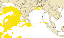
Potential Fishing Zones (PFZ) Advisories provides the information on the location of aggregation of fishes in the ocean using the satellite data. The services is provided on daily basis except during fishing ban period and adverse sea conditions.
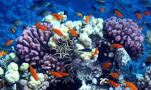
Coral Bleaching Alerts System (CBAS) assesses the thermal stress accumulated in the coral environs using the satellite derived Sea Surface Temperature (SST) This information yields in drawing the early signs of the intensity and spatial extents of coral bleaching. The service CBAS disseminated once in three days comprising the Hotspot, Degree of Heating Weeks and time series products.
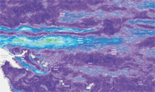
Algal Bloom Information Services (ABIS) detects and monitors the blooms in the Indian Ocean. ABIS provides near real time information on spatio-temporal existence and spread phytoplankton bloom over North Indian Ocean. Daily satellite retrieved standard mapped images of sea surface temperature, chlorophyll, Algal Bloom Index - chlorophyll, Bloom Index, rolling chlorophyll anomaly, rolling sea surface temperature anomaly, phytoplankton class/species, phytoplankton size class and a composite image delineating bloom and non-bloom regions for the above-mentioned region is being disseminated through ABIS.

Multi-Hazard Services
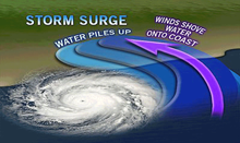
The Early Warning System for Tsunami and Storm Surges, established in 2007, following the devastating Indian Ocean Tsunami on 26th December 2004, provides round the clock services to the coastal population and national and state disaster management agencies. The center detects earthquakes in less than 10 minutes and provides warnings on tsunamis, if any occur, also within 10 minutes of a tsunamigenic earthquakes.
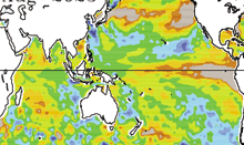
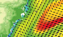
Ocean State Forecasts (OSFs) provides the information on winds, waves, ocean currents, water temperature, etc. at every 3/6 hours on a daily basis for next five days These forecasts are generated using numerical models and used for safety at sea.
High Wave Alerts provides alerts / warnings are provided during extreme / rough weather conditions in the ocean. The service provides details about the coast that may be impacted and duration of high waves, ocean currents, etc.
Search And Rescue Aided Tool (SARAT) developed mainly to find out the most probable Search Area for missing persons/objects at Sea. Users will be able to select 60 types of missing objects such as person in water, life raft, fishing boat, aviation, surf boat, sail boat etc. Users can select a specific Point where the object is missed using the interactive map or they can select a coastal location, distance travelled and bearing angle so that the missing point is calculated. The results generated are shown in an interactive map depicting the probable area to be searched and also send as a text message. SARAT system is mainly to facilitate the Indian Coast Guard, Navy and coastal Security Police in their operations to minimize loss of life, injury, and property damage.

Online Oil Spill Advisory Services predicts the trajectory of oil spill during any event of oil spilled in the ocean. The system uses oil spill trajectory model, general circulation models, atmospheric models and geographical information system. In the case of oil spill, the direction and movement of the oil will be predicted in advance and will be disseminated to the relevant stakeholders for takin up the clean up and control measures.
Small Vessel Advisory Services (SVAS) enhances the safety of the fishermen at Sea, by providing boat-specific safety information to help the fishermen in avoiding the regions that cause capsizing of the boats.
Marine Heat Wave Advisory (MHWA) service on daily basis comprises the parameters Intensity of Marine Heat Wave (IMHW), MHW categories (MHWCAT), percentage of the area of MHW spread over the different basin and sector over the Indian Ocean and south China Sea through the web interface for users. These advisory services can be helpful for understanding the impact of Marine habitat and the frequency and intensity of disaster events for Indian rim country and research communities.
|
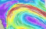
Regional Specialized Meteorological Centre (RSMC)
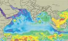
Regional Specialized Meteorological Centre (RSMC)... |
||
|
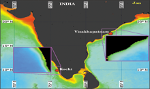
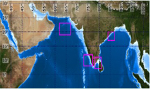
Multi hazard Vulnerability Mapping
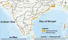
The Multi-Hazard Map is a "composite, synthesized and overlay ... |
||